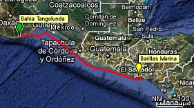
520 nm in about just over 3 days and nights at seaWith our international Zarpe in hand, ready to leave Mexico and start part III of our adventure, in which we will explore the countries of Central America, we got up early on Saturday morning, April 5, and made our preparations to depart Bahia Tangolunda and cross the Gulf of Tehuantepec. The Gulf of Tehuantepec is renowned for its winds, called "Tehuantepeckers", that blow, on average, at Force 8, or gale force, throughout the year. That's an average wind of 40+ knots! The winds occur because this stretch of southern Mexico is a low lying strip just south of the huge Sierra Madre Sur mountain range, and the winds from the Gulf of Mexico build up and funnel over this low lying land and blow into the Gulf of Tehuantepec from the north. Thus they blow from the shore out to sea in this stretch. There are tales of boats being blown hundreds of miles out to sea by winds of 50-60+ knots. The wind is not the only problem though. When the winds blow, they quickly create large, very uncomfortable, and potentially unsafe waves. The farther offshore you get, the larger the waves will be, as the wind has more "fetch" in which to gather up and build the waves. Thus, the usual strategy for crossing this stretch is to keep "one foot on the shore", or, in other words, to sail very close to the beach to minimize the "fetch" and hence the resulting waves. For example, the cruising guide that we have recommends that sailboats traverse the entire 200 miles of the gulf staying within 400 yards of shore, in 30' of water, so that even if it gets windy, one will at least not have huge waves to deal with. Therefore, understandably, we had much trepidation about this next leg. As such, we had waited patiently in Marina Chahue, checking the weather forecast every day, until there was what we felt was a good window of opportunity when we would have a few days respite from those winds to make the crossing. But even when the weather forecast for the Gulf of Tehuantepec looked good, and there was a 4-5 day window where we could expect nothing more than 5-15 knot winds, we still had concerns because there were forecasts for rain and thunderstorms once we had crossed the bay and were off the coast of Guatemala. Our plan was to leave the Huatulco region and sail as much as possible, covering the 500 nm to El Salvador, our longest leg yet, skipping the country of Guatemala entirely and making our next landfall in Bahia Jiquilisco at a marina called Barillas. We had heard that the only place to stop in Guatemala, Puerto Quetzal, was industrial and not very welcoming, and that it was very expensive (about $500) to check into Guatemala even for a few days. Conversely, we had read and heard good things about El Salvador and particularly Barillas Marina, which, apart from being inexpensive, was very pretty and hospitable. However, this being the longest leg we had ever done on RHAPSODY, there was also a question of our range under motor. Would we be able to motor the entire way if we needed to? I had calculated our range, with 144 gallons of fuel, at over 600 nm, but a lot of factors, like contrary winds and currents, can come into play and significantly lessen that range. Plus, one never likes to run a fuel tank on a boat too low, as the rocking of the boat means that the fuel is sloshing around in the tanks and even with 1/4 of a tank remaining, the intake line might find itself above the fuel level, an air bubble could get in the line, and the engine could stop unexpectedly and require bleeding the fuel lines, an unpleasant and potentially dangerous task to undertake at sea. Therefore, while in Marina Chahue, we had also purchased four 5 gallon jerry cans, filled them with diesel and fashioned a secure way to lash them onto the deck. This would give us an additional approximate 100 nm of range. So, at 6:30 am, we pulled up the anchor, and by 7:00 we were motoring out of Bahia Tangolunda, filled with concerns about winds, waves, and fuel range. Our initial plan, to conserve fuel, was to sail as much as possible. That, of course, meant that our average speed would be lower than if we motored all the way. So instead of our usual 6 knot average, I was, for this leg, using 4 knots as an average speed for planning purposes. Thus I was expecting that the 500 nm would take us about 125 hours, or about 5 full days and nights on the water. This is not a long time for seasoned sailors, but for us it was a pretty daunting proposition, especially if we ran into thunderstorms along the way. |
